MarineMate app

What data has been released in the app?
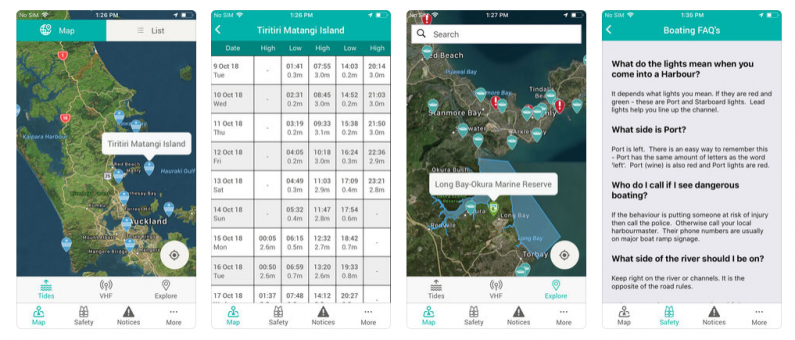
The app contains:
- Tide timetables using the Nautical Almanac from Land Information NZ.
- Boat ramps, 5 knot zones, mooring zones, etc from each council.
- Notices to Mariners from each council and from Land Information NZ advising mariners of important updates affecting navigational safety.
- Bylaws from each council.
Open formats are used (JPEG, CSV, XML, GPS coordinates, KML). The app is a static app so users can access information while on the water without needing cellphone coverage, credit or a plan to access. Where they have cellphone or wi-fi coverage, users update the app prior to going out on the water.
The free app is available for iPhone and Android devices from i-Tunes, Google Play, youtube. A key driver was for the app to be free, without pop-ups and with content and functionality that would enhance safe practices by recreational water users (powered and non-powered craft).
 What are the reasons for release?
Feedback from recreational water users highlighted a number of issues:
- Confusion about what rules applied in different regions, which increased the risk of accidents due to lack of knowledge.
- Boat users did not always know when they had crossed into another region which created compliance and enforcement issues.
- Ignorance of the changing rules were being used as a defence.
- Bylaws were cumbersome in a boating environment and using them on the water may not be seen as ‘cool’.
- A more effective delivery channel was needed to reduce printing costs and increase visibility of the bylaws.
Barriers and mitigations
Seventeen councils, with different formats and variable quality, needed to provide content and have it all changed to a single format (KML). The requirement for a static app (that remained accessible) means that content will need to be updated periodically as a manual process, rather than a direct feed. This is not considered a significant barrier, as the changes are infrequent (eg, annual for the Nautical Almanac, and every few years for updates to regional bylaws).

Future developments
Planned enhancements include:
- Add VHF channels (sourced from CoastGuard NZ) so the local channel can be easily identified.
- Add legislated cable protection zones (sourced from Telecom).
- Embed a generic ‘bar crossing’ film trailer with links to content based on the region.
- Use by NZ Police to provide easy access to current bylaw offence information for enforcement purposes (eg, issue tickets for not wearing life jackets).
Costs
- Development (Dec 2012 to date) $128,000.
- Contributions received from councils, ACC & Water Safety NZ; Land Information NZ and Maritime NZ.
- ACC’s contribution ensured a national coverage for all regions.
Expected benefit
- Improve the transfer of water safety information to recreational water users. Options to assess improvements in water safety practices since the app was introduced are being investigated.
- Reduction in accidents, incidents and costs recorded by ACC for boating related activities that occurred on the water (currently approximately 16,000 accidents pa at a cost of around $33m pa).
- Savings for councils by reducing the number of printed copies of bylaws and educational material.
Economic and social impacts
- Over 14,000 downloads of the app since its launch.
- Recreational users are engaging with Council officers at the boat ramp to learn how to use the full potential of the app, along with positive reviews on website.
- Static app approach increases accessibility for all users as they can access the content without having to rely on being in a cellphone coverage area or having credit on their phone.
- Commercial boat users are also benefiting from the app, preferring it to access Notices to Mariners, as it saves time particularly when working in other regions.
Efficiency impacts
- Waikato Regional Council’s printing costs for the latest update of bylaws reduced from approximately $27,000 to $5,500 as it is actively encouraging the app as the primary delivery channel or the website.
- National coverage has been achieved through a single development process, enabling multiple agencies with a responsibility for maritime safety to build on the app as a delivery channel.
- Feedback via ‘marinemate@waikatoregion.govt.nz’ allows users to easily report errors, suggestions or queries, and has already resulted in improvements.
- Collaborating with agencies with natural connections, eg MetService and its’ weather app, reduces duplication of effort and supports mutual safety objectives.
Transparency outcomes
- Visitors to other regions have confidence they are accessing the authoritative information from a single source. This reduces the potential for different compliance enforcement for residents and visitors in one region.
- Link to NZ Fishing Rules app (Ministry for Primary Industries) and vice versa increases visibility of the rules that water users must comply with.
- Councils are seen to be using a channel that is more likely to be the medium of choice for many recreational water users.
Find out more
This case study was last updated in April 2014.
22 April 2014
Re-use of this case study is licensed under a Creative Commons Attribution 3.0 New Zealand Licence.